Why We Invested in Hohonu: Coastal Flood Intelligence
Coastal cities don’t just need forecasts — they need street-level truth. Hohonu delivers hyperlocal, real-time water and flood intelligence that enables better emergency response and smarter long-term planning for coastal resilience.
As sea levels rise and storms intensify, ports and municipalities lack the granular, real-time data they need to make informed decisions when it matters most. Hohonu bridges that gap with a flood monitoring, alerting, and forecasting platform that fuses ground-truthed sensors with predictive modeling — delivering actionable, street-by-street insights.
We invested because Hohonu translates hydrology into operations, helping protect infrastructure, reduce downtime, and keep communities safe.
Problem
Traditional tide gauges are cost-prohibitive, and regional models can’t capture the block-to-block variability that determines real flood risk. Utilities, ports, and local governments need reliable water-level data and short-horizon forecasts at critical assets — substations, quay walls, pump stations — to better time closures, reroute traffic, and safeguard equipment.
The gap between coarse regional models and on-the-ground truth leads to costly over- or under-reactions, causing millions in damages, operational inefficiencies, and increased risk to people and infrastructure.
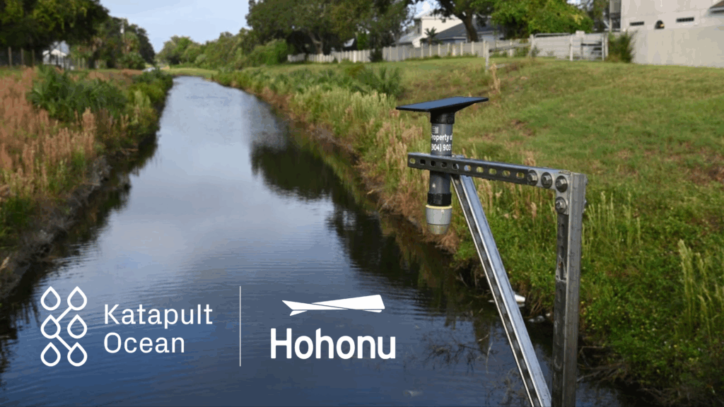
Solution
Hohonu deploys a network of ultrasonic and radar water-level sensors, combining them with physics-based and statistical models to produce site-specific nowcasts and forecasts.
The platform streams alerts and dashboards directly to operations teams and the public, integrates seamlessly with existing SCADA and GIS systems, and provides MRV-ready logs for permitting and resilience reporting. Its edge lies in a repeatable, scalable playbook — rapid installation, automated QA/QC, and analytics tuned for decision-making, not just data.
Customers use Hohonu to shave hours off storm response, protect critical assets, and document avoided losses — turning resilience from a cost center into measurable ROI. Ports can prevent unnecessary shutdowns, and municipalities can direct emergency operations where they will be most effective.
“Hyperlocal, verified water intelligence changes how cities and ports plan, budget, and respond — turning weather into workflow.”
–Anthony Bellafiore, Investment Manager at Katapult Ocean
Impact
By transforming how water-level data is collected and used, Hohonu helps communities reduce flood damage, optimize emergency resources, and quantify avoided losses — creating a financial case for climate adaptation.
Early deployments are already demonstrating shorter response times during storms and fewer costly shutdowns for port operators. As their network grows, Hohonu’s data also supports regional climate models and informs long-term adaptation planning, contributing to safer, more resilient coastal economies.

Why We Invested
We were impressed by Hohonu’s team, which combines deep expertise in hydrology with strong product discipline. They’ve built a solution designed for real-world conditions — calibration, maintenance, and reliability — while keeping the software intuitive and operator-friendly.
Hohonu aligns perfectly with our investment thesis on climate resilience: hardware-plus-software systems that deliver verifiable outcomes to infrastructure owners.
During diligence, we saw disciplined deployments, satisfied operators, and a roadmap that compounds value with every additional site.
We invested because Hohonu delivers the rare combination of dependable sensing, fit-for-purpose modeling, and decision-ready UX — the exact toolkit frontline operators need to protect infrastructure, optimize operations, and safeguard vulnerable communities.
If you’re interested in learning more about Hohonu, or in testing their products, you can get in touch and/or request a demo here.